
What Does the Camera Symbol on Google Maps Mean?
Driving with digital navigation tools has changed how people plan and manage daily trips. However, unfamiliar icons can still cause confusion during navigation. One of the most noticeable symbols is the camera symbol on Google Maps.
When this icon appears during navigation, it can indicate a reported or mapped speed camera or another type of speed enforcement location. Google Maps can show these alerts during active navigation, although availability and features can vary by country and region.
These markers are useful because they give drivers advance notice of potential enforcement areas. They can remind you to check your speed and follow the posted limit. They should not be treated as a guarantee that every camera or enforcement location will appear.
The meaning can also depend on where you see the camera-shaped icon. A camera-related symbol during turn-by-turn navigation is different from a camera button used for photos or visual features.
In this guide, we explain what the camera icon on Google Maps means, how speed-camera alerts work, and why camera-related icons can look different across Maps features and regions.
What is the camera icon on Google Maps?
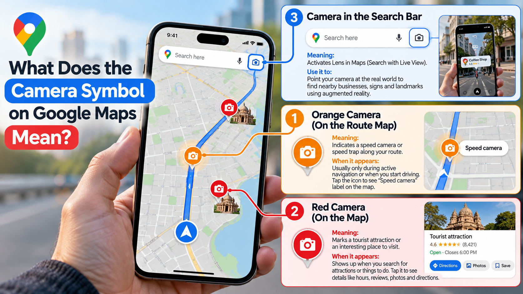
The camera icon on Google Maps can identify a speed camera or reported speed enforcement location during navigation. It is designed to give drivers advance notice of a potential enforcement point along their route. Speed-camera information may come from map data or reports made by Maps users, depending on the location and feature.
When the icon appears on your route, use it as a reminder to check your speedometer. Follow the posted speed limit rather than relying only on the information shown by Google Maps.
The feature is generally associated with active navigation rather than ordinary map browsing. Google Maps users have reported seeing speed-camera markers while following a planned route. Availability can differ between countries and regions.
It is also important to understand that the camera icon does not mean Google has detected a camera in real time. Map information can change, and user-reported information may not always be complete or current. If you are comparing navigation apps, understanding the differences between Google Maps and Waze can also help you choose the right tool for your driving needs.
Audio Warnings for Speed Cameras
Google Maps can provide alerts related to reported road incidents and speed-camera locations in supported areas. However, the exact alert behavior can vary by device, region, app version, and navigation settings. Google Maps users have also reported situations where the camera icon appeared without an audible warning.
Because of these differences, you should not depend on an audio alert alone. Keep your attention on the road and follow the speed limit shown on road signs. If you use Android Auto, Android Auto Gemini voice commands can also help you interact with navigation features while keeping your attention focused on driving.
If you are expecting an alert but do not hear one, check your navigation sound settings. Google Maps may also have different alert availability depending on your location.
The safest approach is simple:
- Keep navigation audio enabled when appropriate.
- Watch the road and posted speed-limit signs.
- Treat camera markers as helpful information, not a guarantee.
- Avoid using your phone while driving.
These steps make the feature useful without turning it into your primary safety system.
What does the orange camera symbol mean on Google Maps?
The orange camera symbol on Google Maps is often described online as a speed-camera warning. However, Google does not provide an official universal color guide stating that every orange camera icon has one specific meaning.
This distinction matters because Google Maps uses colors for several different map features. For example, Google’s official Maps documentation states that orange road lines can indicate medium traffic. That color does not mean a speed camera.
If you see an orange camera-shaped marker during navigation, the most useful interpretation is to look at its context. If it appears as a camera or speed-enforcement marker on your active route, it may represent a reported camera location.
Do not assume that the color alone identifies the type of enforcement device. The exact appearance can change with the Maps interface, platform, location, and feature.
Instead, focus on the symbol’s location and context. Most importantly, follow the posted speed limit and local traffic rules.
Distinguishing Live Route Hazards
Google Maps displays several types of alerts during navigation. These can include crashes, construction, road closures, traffic slowdowns, and other reported incidents. The official Maps legend confirms that traffic incidents have their own symbols and that traffic colors indicate traffic speed.
A camera marker should therefore not be confused with a general traffic warning. Its presence on your navigation route can point to a reported camera or speed-enforcement location.
The best way to interpret the alert is to consider what symbol appears, where it appears, and whether you are actively navigating.
Remember that map data can change. A reported camera may be missing, outdated, or unavailable in a particular region. Google Maps does not replace official road signs or local traffic information.
If you see a camera marker, use it as an additional reminder to drive carefully. Do not suddenly brake because of an icon. Maintain a safe speed and follow the road conditions around you.
What does a yellow camera mean on Maps?
There is no reliable Google documentation showing that a yellow camera on Maps has one universal meaning across all versions and regions. Search results and user discussions may describe different colors, but those descriptions should not be treated as an official Google Maps color code.
Google’s official Maps documentation explains several traffic colors. Orange indicates medium traffic, while red indicates traffic delays. These colors describe road traffic conditions rather than camera enforcement.
Therefore, seeing a yellow or orange camera-shaped marker does not automatically mean it is a red-light camera, speed camera, or mobile radar unit.
The symbol’s context is more important than its color. If it appears during active navigation near your route, it may relate to a reported speed or enforcement location.
Google Maps features can also vary by country and region. Some reporting and alert features are not available everywhere.
For safe driving, treat any enforcement warning as a reminder to follow the posted limit and local traffic rules.
Regional Differences in Camera Color Palettes
Google Maps does not provide a single public color guide that assigns a specific enforcement meaning to every camera color. This makes it risky to claim that yellow always means one type of camera.
The appearance of map markers can vary with the Maps interface, device, location, and available features. Some camera information may also depend on local reporting and regional availability. These differences are one reason it can be useful to understand how Apple Maps and Google Maps compare across navigation features.
Google Maps users have reported differences in the availability of speed-camera alerts between locations. Community discussions also show that camera alerts can disappear or behave differently after updates.
For this reason, avoid interpreting a camera marker solely by its color. Instead, consider whether you are in active navigation and what the marker represents on the route.
If the icon appears near a known enforcement location, reduce distractions and follow the posted speed limit. Do not rely on the marker as a complete list of cameras.
The most dependable source for driving restrictions remains the road signage and traffic rules in the area where you are driving.
What does the camera icon mean?
The meaning of a camera icon in Google Maps depends on where the icon appears. During turn-by-turn navigation, a camera-shaped marker can relate to a speed camera or reported speed-enforcement location. In other parts of Maps, camera buttons can have completely different purposes.
For example, Google Maps lets users interact with photos and visual information for places. A camera-related control in a place, review, or photo interface can be associated with adding or viewing images rather than road enforcement.
This difference is important because the same general camera shape does not necessarily represent the same feature everywhere in the app.
If you are driving and see a camera marker directly on your navigation route, consider it a possible road-enforcement alert. If you are browsing a business or landmark, a camera button is more likely related to photos or visual content.
When in doubt, check the surrounding interface and the context in which the icon appears. Most importantly, never interact with your phone while driving unless it can be done safely and legally.
Uploading Helpful Photos for Local Communities
Google Maps also includes photo features that let users contribute visual information about places. These photos can help other people understand what a business, landmark, or location looks like before they visit. If you regularly contribute photos or other information, you may also wonder whether contributing to Google Maps can earn rewards or recognition.
For example, useful images can show a storefront, entrance, menu, parking area, or interior. Clear and relevant photos can make local listings easier for other Maps users to understand.
However, this photo feature should not be confused with the camera symbol on Google Maps that appears during navigation. A camera button for uploading or viewing photos serves a different purpose from a camera marker associated with road information.
The easiest way to tell them apart is to check where the icon appears. A camera marker on your driving route relates to navigation information. A camera control near photos or place details relates to visual content.
Understanding this distinction can prevent confusion when switching between navigation and ordinary Google Maps browsing.
Conclusion
Understanding the camera symbol on Google Maps can make navigation less confusing, especially when you are driving through an unfamiliar area. In most navigation situations, a camera marker can indicate a reported speed camera or speed-enforcement location along your route.
However, do not assume that every camera icon or color has the same meaning. Google Maps uses different symbols across its navigation, traffic, photo, and place features. Camera colors can also vary by region, interface, or feature.
The safest approach is to treat camera alerts as helpful reminders rather than guaranteed warnings. Always follow the posted speed limit, traffic signs, and local driving laws. Google Maps can support safer navigation, but it should never replace your attention to the road.
For a complete explanation of Google Maps colors, symbols, traffic indicators, and map features, you can also refer to the official Google Maps Help guide.
Once you understand the difference between navigation camera markers and photo-related camera buttons, these icons become much easier to recognize and interpret.